
Long route. Clear progress.
MarchMap
MarchMap is an app for long walking routes based on GPX files. It shows the route on a map, your position along it, how far you have covered and how far remains, plus an elevation profile and details for sustained climbs — without recording a track of its own.
The idea behind the project
MarchMap grew out of a very specific problem with long walking routes: while covering the distance, you want to understand not only how far you have physically walked, but exactly where you are on the planned route and how much of it remains.
This matters especially on a long-distance march. You may briefly leave the track, take a detour around a closed section, or make some other small diversion. The distance you have actually walked then starts to differ from the official route length, making it difficult to tell how many kilometres truly remain to the finish along the original GPX.
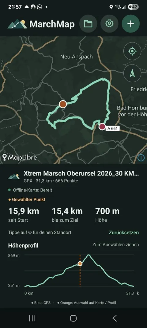
MarchMap works from the route itself. The app opens a GPX file, displays it on a map, builds an elevation profile, and determines the user’s position relative to the route line. If the current position lies on the route, you can immediately see how many kilometres are behind you, how many are ahead, and where you are on the elevation profile.
MarchMap deliberately does not record its own track or monitor movement continuously. It uses the current location only when it needs to determine where someone is in relation to the route loaded in advance. This is particularly important on long marches and hikes, when a phone needs to last for many hours: continuous GPS recording uses a noticeable amount of battery. With MarchMap, you can open the app, locate yourself, check the route, and put the phone away again.
You can also select any point on the route manually. MarchMap shows how many kilometres it lies from the start and how much distance remains after it, and marks the same point on the elevation profile. This is useful when you want to see where a climb ends, how far it is to a particular section, or what terrain lies ahead.
For sustained climbs, the app can also show how far remains to the top, both in distance and elevation gain. On a long route, information such as “1.1 km and +400 m to go” is often more useful than the current elevation or the full profile alone.
A route can be prepared in advance so the required map area remains available without a network connection. When internet access is available, the map can load as usual. If the connection drops, the GPX route, elevation profile, calculations, and preloaded map area continue to work.
The central idea of MarchMap is simple: show not where someone has already been, but where they are on the chosen route and what still lies ahead.