
MarchMap

For the long way ahead

Know where you are on the route.
Without tracking every step.

Open a GPX route, check your position, and see the distance remaining and elevation profile — without continuously recording your route.

In the Android app · no account · no recorded track

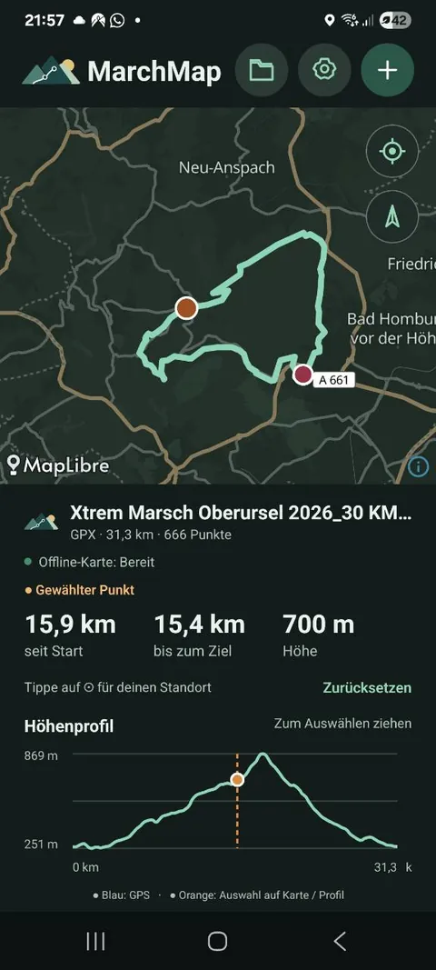
MarchMap: a GPX route on a dark map, a selected point, and an elevation profile.
Actual Android app screen
30km
50km
100km

For endurance walks, extreme marches, and every long day on the trail.

01 / Out on the route

Made for long-distance walks

On a 30, 50, or 100 km walk, the total distance you’ve covered isn’t the only thing that matters. Often, the real questions are:

01

Where am I on the official route?

02

How many kilometres are still ahead?

03

What does the elevation profile have in store?

MarchMap shows you exactly that — using the GPX route you’ve loaded.

02 / The route is your reference

Your progress along the planned route

Small detours happen: a toilet stop, an aid station, roadworks, a wrong turn.

That’s why MarchMap calculates your progress from the planned route, rather than the track you’ve actually walked. You can still see:

  • Kilometres from the start
  • Kilometres left to the finish
  • Your position on the elevation profile
  • The elevation at your current point
Planned routeSelected point
15.9 kmfrom the start
15.4 kmto the finish
700 melevation
Route illustration · example values

Less GPS. More battery.

MarchMap doesn’t record your movement continuously. When you want to know where you are, check your position, glance at the route and profile, then put your phone away again.

On long walks, that helps avoid unnecessary battery drain from continuous tracking.

Tap any point on the route

Want to know how far it is to a particular section? Just tap the route. For that point, MarchMap shows you:

  • Distance from the start
  • Distance remaining to the finish
  • Elevation and position on the elevation profile

A quick way to get a sense of what’s still ahead.

03 / Uphill, one step at a time

Another 1.1 km and 400 m up to the top

Long climbs feel more manageable when you know how much is left. On longer, significant climbs, MarchMap can show how far you still have to go before the climb ends.

Not every little hill counts as a climb. Detection takes both length and gradient into account.

1.1 km · +400 mRemaining to the end of the climb
Example climb · illustrative elevation profile
04 / Set off prepared

Works without a signal, too

You can prepare the map along your route before you set off. Your route, elevation profile, and the key map areas then stay available even when there’s no mobile signal.

01

Offline only

Use prepared maps without downloading more map areas on the go.

02

Offline + online

Use prepared maps and add online coverage when needed.

03

Fully online

Load maps using an internet connection.

No account. No tracking history. No backend needed.

MarchMap is deliberately simple. Open your route and use it.

  • No registration
  • No movement history
  • No recorded track of your own
  • GPX processing on your device
  • No ads

For endurance events, night walks, and long days on the trail

MarchMap is made for those days when you’re out for hours and don’t want to keep navigating. A quick glance is enough:

Where am I?How much further?What’s the elevation like ahead?

Load your GPX. Know your route. Keep walking.

MarchMap is available for Android. iOS is planned.

Download MarchMap

Repository on GitHub